• This forum is the machine-generated translation of www.cad3d.it/forum1 - the Italian design community. Several terms are not translated correctly.

scan 3d a room (maximum) with cell phone and app, can you?

  • Thread starter Thread starter ragnol
  • Start date Start date

ragnol

Guest
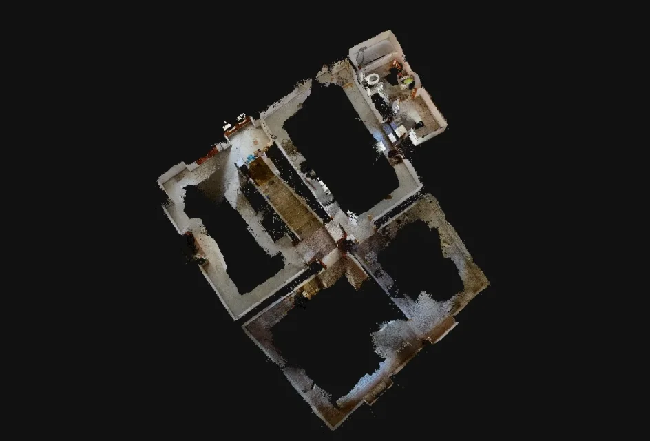
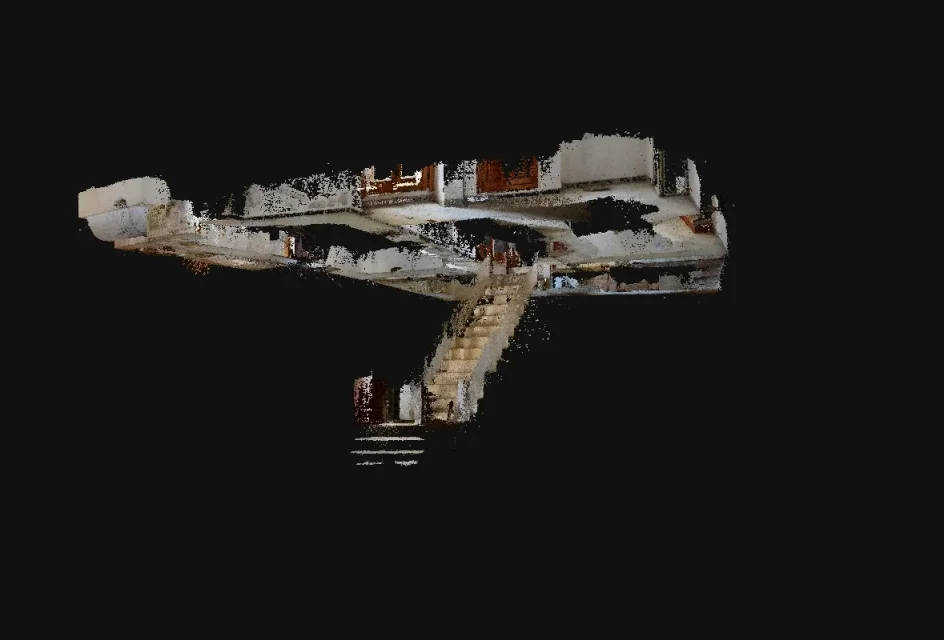
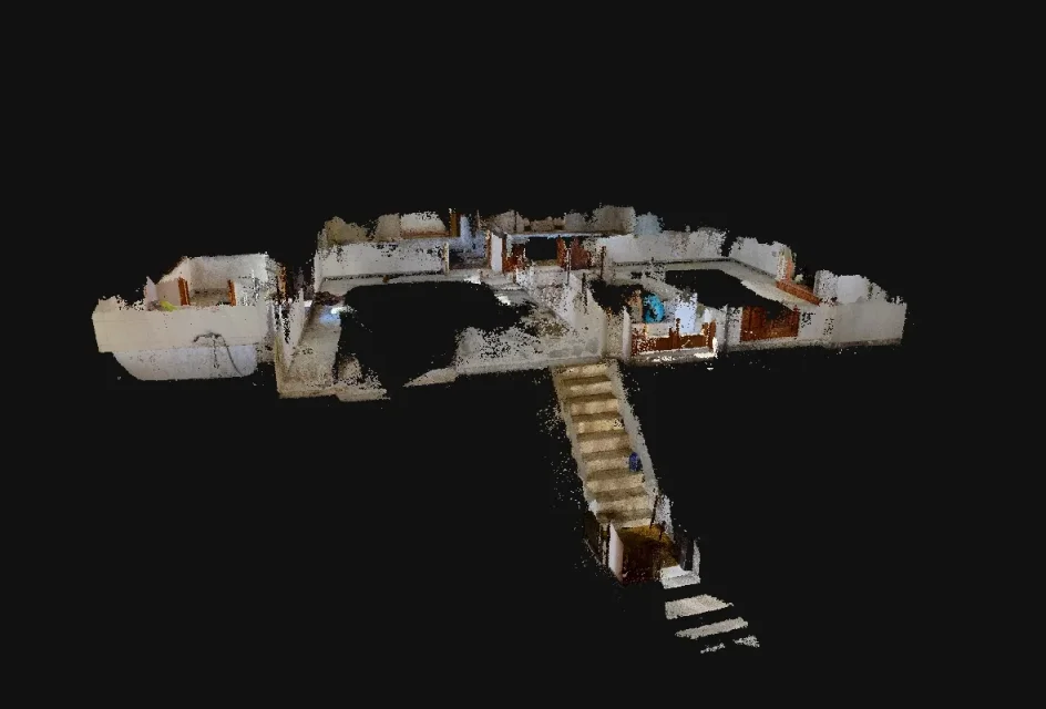
As from title, did we get to the possibility to scan 3d of maximum of a room with x mobile photo (magari mounted on rotating stable support) and app?

I use a total leic station with lasers, but every bishop's dead I happen to have to intervene in a room with old walls (then leaning and falling stones) and a lot of twists, and a 3d relief with tolerance to the centimeter (therefore, but also more) would make me comfortable.

sooner or later I will take the blk360, but in the meantime.. .
 
for an uncomfortable room a 3d scanner from 16 thousand euros?
some time ago I read about rollingport, but I never deepened the topic
 
maximum scans can be done, in the sense that some photogrammetry programs allow to obtain mesh or only highlights.
what I used years ago is photomodeler but there is also the autodesk imagemodeler.
can work automatically, i.e. create a mesh from the images, or manually extract the highlights that most interest us to then join them with lines.

I used it to detect the outside of a canton house. I first made a series of photos all around the building, then I tried to get a mesh.
the mesh did not come out, then I decided to choose points that allowed me to draw a prospect. It was a work of Carthonians, but it came out well.

it is not always possible to take pictures that allow to get a mesh. things get a little bit complicated. I don't know if the phone is possible. the photo should contain as many information as possible on the surface of the walls, otherwise the mesh is not created or created incomplete.
in some videos I saw that they use good lights and an auction.

But there are machines that also associate the laser with the photos, precisely for the internal relief.

-
 
@tristus I'll try to get into what you wrote to me. Of course, the final result I would like is to have the room in cad (points, mesh, boh...).
@cristallo we do (spannometrically) from 100 to 150 reliefs per year, and in some situations I have to make more stations to connect areas that are not seen from a single station (recently an old hotel, therefore internal-external with the inside occupied by n° rooms and bathrooms with relative plots, plan of the pillars not regular and therefore it detects everything for having the position. when buildings are historical (40% of total), old, badly put, decrepits etc. I still have to choose what to detect and what to neglect (otherwise I would make 10 days of relief). with the 3d scanner I should maybe make more stations, but I would have the position of every single element of the building (pilastro, barbacani, beams, roof structure, lead-out walls, protruding of a cord, etc.).

I do not deny that it is an investment that with the owner sometimes we hypothesize.
 
some time ago I read about rollingport, but I never deepened the topic
This is a 3d virtual tour made with a rollingport.
It's a mix of photogrammetry and laser, which is, I think every photo taken contains information from laser. I think the machine used is a rollingport.

But for the reliefs it is necessary to have measures. I don't know how long this technique serves for a classic relief, where a 3d environment can be reconstructed with real measurements.
 
this product no longer exists for several years
I tried them both, but photomodeler seemed superior to me in the options.
the advantage of photomodeler is that you don't have to process photos to get a mesh.
Let us put the case that one simply wants to get some points from the photos that allow to draw some prospectuses through lines, without extracting any mesh.
can do it manually by marking the points that interest in each photo (walls, windows, doors etc.). always from program unites them and creates plans (walls etc.) without any processing of photos, only a job marking points. If you want, you can texture the flat surfaces so obtained. the program texturizes according to the photos taken.

in the video tutorial, the operator still performs an automatic processing of the photos, not to get a mesh but to help the program in search of the points in all photos.
through this pre-processing, you are able to locate a spot marked on a photo in all others, easily. It is a help that allows you to easily identify the point marked in the remaining photos so that the operator does not waste time searching and marking, because the point marking operation must still be done manually (in this case).
But if you want the program, you can skip this step and you switch to the totally manual marking.

At the end you can also get a video animation by setting a path.
 
Yes, it is possible. if you need only size and shape of the room there are special software for this purpose. if you need to get a 3d model of the room, or anything else, all you need is a camera and special software, your phone camera will definitely work, the process is called photogrammetry, here you can read how it works.
 
(what in jargon is called spannometric relief)
I read some reviews about the apps in question. someone complained that it was not possible to add diagonal measures.
that would seem (use the conditional) that can be easily detected those environments that have right angles, but in the case of environments outside the team, like old houses, the relief is not possible. That's what seemed to me to understand.

On the other hand, from a simple mobile phone you cannot expect too much, while those tablets dedicated to this type of work should be good, which, together with purely aerophotogrammetric procedures, also combine a laser function. a cell phone does not have laser
 
I also had the same need, after endless initial tests I managed to get the perimeter of the interior, room by room of an old house in granite blocks. not having the need to recreate the mesh of the walls in all their height I limited myself to taking pictures only at the points where the floors meet the walls.
It's been a long time since I wanted to detect that old house full of huge off- team.
a photographic relief that has committed me for half a day. I was alone, so I'm going to have to go back with a colleague to take two measures that will serve to properly scale the cloud.

for convenience it is better to work on the scattered cloud from which to get the corners and the straights that will identify the perimeters of the rooms, then exportable to dxf.
to do this download a photogrammetry program like the 3dflow zephir or similar. trial versions allow you to achieve good results, while with some limitation.

being internal, the mobile phone is not indicated. the sensors of these devices are small and give discrete results (for the purposes of tracking points) only with good brightness conditions. in the interior the mobile phones will return photos that the program will make to process, with the risk that you do not accept photos. for here if you want acceptable results evaluates the purchase of an entry level reflex.
in the interior I was forced to place the reflex on the stand, with f7 aperture

(for a good depth of field better take from f7 up. the shutter speeds will therefore be extended for which it is necessary the easel, penalty the move. the machine in this way will capture more details necessary to the point tracking program. Moreover, it is necessary to have a precision at cm. the photos of the cell phone are not the maximum.
 

Attachments

  • screenshot.webp
    screenshot.webp
    60.4 KB · Views: 12
  • screenshot2.webp
    screenshot2.webp
    52.5 KB · Views: 12
  • screenshot3.webp
    screenshot3.webp
    57.4 KB · Views: 12

Forum statistics

Threads
44,997
Messages
339,767
Members
4
Latest member
ibt

Members online

No members online now.
Back
Top