• This forum is the machine-generated translation of www.cad3d.it/forum1 - the Italian design community. Several terms are not translated correctly.

topographic plant with 3d level curves

  • Thread starter Thread starter Reemul
  • Start date Start date

Reemul

Guest
health at all

I predict that my work is other (I'm mediatistic) but I have an interest in understanding the functioning of gis and 3d graphics programs to implement my work with the new tools.

I have practically no experience in the field I've been "setting" for days on the internet trying to understand the basics but how always to ask some direct question could shorten my time.

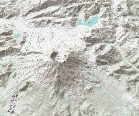
In summary, my problem is as follows: I have the need to reconstruct in 3d a topographic plant of some areas of the lazio in which however there are curves of level. the latter are fundamental because they attest a "scientific" reconstruction of the area. I downloaded itopo20 plants and I'm trying to make them work under 3dem but without great results. I would like to attach an image of what I would like to achieve at least in its general lines.

I hope I've been quite clear. every suggestion is well accepted even in the change of programs (currently use arcgis, google earth, 3dem)
Thank you all for your help!
 

Attachments

  • MtStHelens_VE_3D.webp
    MtStHelens_VE_3D.webp
    66.3 KB · Views: 17
azz 45 visits and no answers? Did I say bad, or does it not seem to be a solution?
 
azz 45 visits and no answers? Did I say bad, or does it not seem to be a solution?
There may be a thousand solutions but I doubt that you can explain in a few lines on a forum, especially given your "experience" on such systems. I see it in this way: or do you overdose of topography, cartography and gis (and we resent you in a few months) or let do this kind of thing to those who have studied and "smanettato" for a long time. as if I wanted to try archaeology just because I saw Indian jones...
 
There may be a thousand solutions but I doubt that you can explain in a few lines on a forum, especially given your "experience" on such systems. I see it in this way: or do you overdose of topography, cartography and gis (and we resent you in a few months) or let do this kind of thing to those who have studied and "smanettato" for a long time. as if I wanted to try archaeology just because I saw Indian jones...
as logic does not bend and sincerely thank you for having responded. The problem, as I see it, is that as an answer it seems to me a little bit of "washed hands". I feel like I feel banks giving money only to those who have it and at that point loans are virtually useless. . .
if you know the program (or programs) it is useless to stay on the forums to ask questions not? one asks experts just to be addressed then it is clear that the work I have to do it myself. If I was asked how a stratigraphic excavation works, I wouldn't answer a few months ago to study archaeology, and only then I'll tell you that my answer would be useless. I said that I renew my thanks at least you answered me. :finger:

greetings
 
if you know the program (or programs) it is useless to stay on the forums to ask questions not?
I just want to point out that the "knowledge" of the software is not binary, there are various degrees of ability in use, so one who knows the software may still need a couple of straights that can be summed up in a post; something different is to do a matching course through the requests posted on the forum (difficultly you will find someone willing to do it)
If I was asked how a stratigraphic excavation works, I wouldn't answer a few months ago to study archaeology, and only then I'll tell you that my answer would be useless.
how it works is one thing, how to do it is another...I would like to see you as you would explain to a complete ignorant (in the sense that it ignores matter) in a few lines how to deal with a stratigraphic excavation. . .
 
how it works is one thing, how to do it is another...I would like to see you as you would explain to a complete ignorant (in the sense that it ignores matter) in a few lines how to deal with a stratigraphic excavation. . .
from it is not as difficult as what: I would say to take a look at harris (principles of stratigraphic archaeology) and carandini (historics of the earth) then I would recommend a couple of sites like archeoserver.it or medieval archaeology.it and to finish illuminate briefly what is a trowel, a level and a lead thread (the main tools of work) and what is intended for stratigraphic units. :smile:

I don't want to raise arguments for charity but only show that an explanation is not so difficult to give especially to a neophyte: I remembered what came to mind in 15 seconds. You are absolutely in reason when you give me some ignorant because, and I am not ashamed, of the subject I know very little. but what does an expert use if he can't direct a neophyte even to understand the basic issues like that program to start seeing? I repeat I do not want you (or who for you of course) to do my job or to explain step by step what to do, I would simply like an expert to direct me to some possible solution.
soon
 

Forum statistics

Threads
44,997
Messages
339,767
Members
4
Latest member
ibt

Members online

No members online now.
Back
Top