
• This forum is the machine-generated translation of www.cad3d.it/forum1 - the Italian design community. Several terms are not translated correctly.

definition of the 3d model of a territory based on a 2d design

giada0

Guest
Hello.
I have a dwg 2d file of a city, formed by 3d polylines that follow the various soil levels (for example if they select a line belonging to one side of the road, this in the front view follows a descent). I would however need the 3d model of this territory which is based on this data.
if you can use this file for creating the 3d model, what commands should I use?
if instead it is not possible to use this file, what would be the most intuitive way to model this territory?
I thought I would use autocad for modeling, but if there is any other program more suitable for a job of this kind I accept advice!
Thank you.
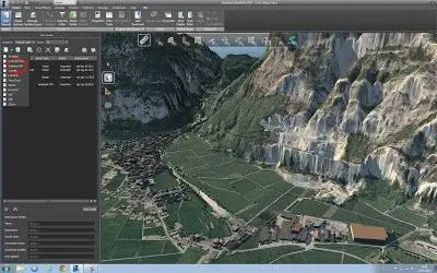
 
I don't understand what you call "poliline 3d" is the level curves? Are they 2d or 3d?
 
in the properties indicates it as polylinee 3d. are not level curves, in the view from above is as if I had the 2d cartography of the city without level curves, but only the profiles of roads, palaces etc. in frontal views I don't have everything on the same level, but these lines follow the various slopes.
For example, to reconstruct a stretch of road I have two parallel segments in the view from above, in front view these follow two different slopes; putting me from the top, if I connect them with a perpendicular segment, in lateral view I will also have the "pendence of the width of the road", which will change flowing according to the first two. thanks to this information I would like to know if it is possible to reconstruct a 3d model of the soil.
 
so this information certainly does not lead to anything? will I be forced to look for more information to rebuild the city model?
 
To reconstruct the 3d model of a city, at least 3 things are necessary in my opinion:
  • dtm or level curves
  • contour manufactured
  • Road routes
possibly can return useful the orthophoto of the area to be reconstructed.
02.webp
 
I refer to the debate because the problem is similar to mine, but I have only the map in 2d with isoipse and manufactured contours. for the thesis I have to make a 3d model of an entire country that will only serve me as an illustration of the context of the real project. At first I thought I would do it with revit, but I soon realized that it is not the most suitable software for such an enterprise. which software best suits this situation? what is the easiest to learn?
 

Forum statistics

Threads
44,997
Messages
339,767
Members
4
Latest member
ibt

Members online

No members online now.
Back
Top